The volcanoes that made Cappadocia's landscape
Why do Cappadocia's fairy chimneys and valleys look the way they do?
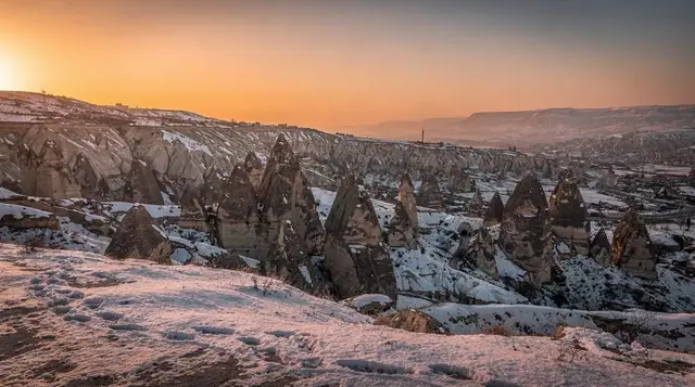
Cappadocia's landscape formed from thick volcanic ash and tuff erupted by Erciyes and Hasan Dağı over several million years, later carved by wind and rain. Fairy chimneys survive where a harder basalt cap protects a softer tuff column beneath it, and valleys like Rose or Red Valley show different colours because their tuff layers contain different minerals and iron oxides.
How a volcanic plateau became fairy chimneys
Almost everything a visitor photographs around Göreme starts with the same fact: this part of central Anatolia sits on a plateau built almost entirely from volcanic material. The valleys, the cones, the underground cities and the cave hotels are all carved into the same soft rock, and that rock has a single origin story. This guide explains that story rather than describing any one site to visit — it is meant as background you can carry into the Göreme open-air museum or a walk through Rose Valley, not a replacement for those guides.
Two volcanoes, one long build-up
Cappadocia’s landscape was built by two volcanoes rather than one. Mount Erciyes, 3,864 m and the higher of the pair, stands near Kayseri on the eastern side of the region. Hasan Dağı, 3,253 m, sits further west, beyond Aksaray, closer to the Aladağlar range. Both are stratovolcanoes, and both were active over a long period spanning several million years, with eruptions that overlapped rather than following one another in a clean sequence.
Neither volcano produced one dramatic eruption that buried the region overnight. Instead, repeated eruptions over that long span deposited ash, pumice and other volcanic fragments across the plateau in layers, some thin, some many metres thick, laid down at different times and from different vents. That layering is the reason the rock under Cappadocia is not uniform: drive between villages and the tuff visibly changes colour and texture from one valley to the next, because you are crossing between deposits from different eruptive phases.
| Volcano | Height | Location relative to Göreme | Status |
|---|---|---|---|
| Erciyes | 3,864 m | around 1 h 15 by road, near Kayseri | dormant |
| Hasan Dağı | 3,253 m | west of the plateau, beyond Aksaray | dormant |
Both volcanoes are classed as dormant, not extinct. There is no current monitoring advisory that affects travel, and neither has a confirmed eruption in recorded history, but geologists do not rule out future activity on either.
From ash to rock: how tuff forms
The material that fell across the plateau was mostly volcanic ash, along with pumice fragments and larger blocks thrown out during more explosive phases. Over time, and under the weight of further deposits piling on top, that loose ash compacted and cemented into a soft, porous rock known as tuff, or tüf in Turkish. Tuff is Cappadocia’s foundation rock in the most literal sense: the plateau’s plains, its valley walls, its cones and its fairy chimneys are almost all cut from it.
Tuff has two properties that matter more than any other fact in this guide. First, it is soft enough to carve by hand — which is why the region’s underground cities at Derinkuyu and Kaymaklı, its cave churches, and its cave hotel rooms could be excavated with basic tools over centuries rather than blasted or drilled. Second, that same softness makes it vulnerable to weather. Rain, meltwater and frost work into the rock and wear it away steadily, which is the process that carved the valleys and is still carving them now.
Not every layer eroded at the same rate. Some eruptions also produced basalt or other harder volcanic rock, either as lava flows or as denser, welded layers of ash. Where a resistant layer sits on top of softer tuff, it protects what is underneath it from rain while the exposed tuff around it wears away — and that mismatch in hardness is the direct cause of the fairy chimney.
The fairy chimneys: how a boulder becomes a roof
A fairy chimney, peribacası in Turkish, is a column of tuff that has survived erosion because it is capped by a block of harder rock, typically basalt. As the surrounding softer tuff wore down around it, over what geologists estimate at hundreds of thousands of years for the broader plateau shape and a much shorter, ongoing timescale for any single chimney, the column beneath the cap was shielded from direct rainfall and eroded far more slowly than the rock around it.
The result is the narrow pillar with a dark stone hat that has become the visual shorthand for the region, seen most densely in Pasabag, known in English as Monks Valley, and in Devrent Valley, where a similar process produced shapes without any caps or man-made carving at all.
This process is not finished. It is happening on a slow but continuous basis: caps slip, columns get undercut too far and topple, and new candidates for the next generation of chimneys are already forming as their neighbours erode away around them. It is also why walking off marked paths in the valleys is genuinely unsafe rather than just discouraged — tuff overhangs and slopes that look solid can be more unstable than they appear, a point covered in more detail in the region’s hiking safety guide.
The same instability explains the abandoned upper village above Çavuşin, fenced off after decades of rockfall made it unsafe to inhabit, and it is a factor local guides mention when explaining why the dark church at the Göreme open-air museum, Karanlık Kilise, needed a separate, more sheltered excavation to preserve its frescoes.
Why the valleys are different colours
One of the more useful things this geology explains is a question most visitors ask without quite framing it this way: why does Rose Valley look pink, Red Valley look red and orange, and other valleys nearby look pale grey or white. The answer is mineral content, not lighting or a trick of the eye, though the low sun at either end of the day does intensify the effect, which is why sunset is the recommended time to see Red Valley and why the same walk through Rose Valley reads differently in the morning.
Each valley exposes tuff from a particular layer or set of layers, and those layers differ in the minerals they carry, especially iron. Where the tuff is rich in iron oxides, weathering turns the exposed rock pink, red or orange — the more oxidised the iron, the deeper the colour. Where the tuff is comparatively iron-poor, or where a different mineral dominates, the rock weathers to white, cream or grey instead, which is the case in White Valley and much of Love Valley and Pigeon Valley.
| Valley | Typical colour | Likely cause |
|---|---|---|
| Rose Valley | pink to salmon | iron oxide content in that tuff layer |
| Red Valley | red to deep orange | more heavily oxidised iron content |
| White Valley | pale grey to white | iron-poor tuff, different mineral mix |
| Love Valley, Pigeon Valley | grey to buff | mixed, generally lighter tuff |
| Devrent Valley | grey with darker caps | tuff plus scattered volcanic boulders |
None of this is uniform even within one valley. A single cliff face in Rose Valley can show several bands of colour stacked on top of each other, because it is exposing several eruption layers at once, deposited at different times with different mineral content. That banding is worth pointing out to anyone who assumes the colour is a single dye running through the whole rock rather than a record of separate eruptions.
The plateau’s other volcanic byproducts
Tuff is the headline material, but it is not the only thing the region’s volcanic history left behind. The clay worked by potters in Avanos, on the banks of the Kızılırmak river, is itself derived largely from weathered volcanic sediment washed down from the plateau, which is part of why the town has worked clay continuously since Hittite times rather than importing it. Basalt boulders, harder and more resistant than the surrounding tuff, are scattered across several valleys as the caps of collapsed chimneys or as material thrown further by more explosive eruptions, and they are the reason a small number of chimneys are noticeably darker-capped than their neighbours.
The volcanic soil itself also shapes the region above ground, not just below it. Cappadocia’s old vineyards, planted in the porous, mineral-rich volcanic soil around Ürgüp and Nevşehir, are frequently cited by local winemakers as a reason for the character of grapes such as Emir and Kalecik Karası, though that is a claim about wine character rather than a settled geological finding.
Seeing the source rather than the result
Most visits to Cappadocia focus on what erosion produced — the chimneys, the valleys, the underground cities — without a clear view of the volcano that supplied the raw material. Mount Erciyes is the more accessible of the two, roughly 1 h 15 from Göreme near Kayseri, and it is possible to get considerably closer to the mountain itself on a guided day out rather than viewing it only as a distant backdrop from the valleys.
a day trip up Mount Erciyes with transfer from Göreme is the most direct way to stand on the volcano that produced most of the region’s tuff, and in winter it doubles as the region’s ski access, since Erciyes carries Turkey’s largest ski area on its slopes. For a slower, closer look at exposed tuff layers and basalt caps without leaving the valleys around Göreme, a guided mountain bike route through Rose and Red Valley covers more ground than walking while staying close enough to the rock faces to see the colour banding described above.
For visitors who want the whole picture in one outing — valley colour differences, fairy chimney formation and a comparison between tuff regions — a full-day guided tour taking in several of the main valleys is the most efficient option, and a guide on the ground can point out details, like a fresh chimney collapse or an unusually thick colour band, that are easy to miss unprompted. A more relaxed alternative that still gets close to the rock is a classic car tour through the valleys around Göreme, which stops at several viewpoints without the walking a hiking day requires.
Reading this into the rest of a Cappadocia visit
None of the region’s other guides need to repeat this material, and this one is not meant to replace them. The point of setting the geology out separately is that it explains details those guides mention in passing without dwelling on: why Derinkuyu’s underground city could be dug eight levels deep using only hand tools, why guides describing Mount Erciyes treat it as a source rather than a viewpoint, and why the region’s best photography spots, catalogued in the Cappadocia viewpoints guide, tend to be wherever a valley wall exposes the most colour banding in the clearest light.
Understood this way, a walk through any one valley stops being a single, self-contained sight and becomes a cross-section through a much longer process — millions of years of eruptions from two named volcanoes, compacted into a rock soft enough to carve and hard enough to stand in columns, and still eroding, one collapsed cap and one undercut column at a time, exactly as it has for as long as the region has looked like this.
Common questions about Cappadocia’s volcanic landscape
What created the Cappadocia landscape?
Two volcanoes, Erciyes and Hasan Dağı, erupted repeatedly over several million years and buried the region in thick layers of volcanic ash and pyroclastic material. That material compacted into a soft rock called tuff. Wind, rain and the region’s rivers then cut into the tuff plateau, carving the valleys, cones and fairy chimneys visitors see around Göreme today.
Why are Erciyes and Hasan Dağı important to Cappadocia’s geology?
Erciyes, at 3,864 m near Kayseri, and Hasan Dağı, at 3,253 m on the western side of the plateau, were the two main sources of the ash and lava that built up the tuff layers under Cappadocia. Their eruptions overlapped over a long period, which is why the tuff varies in thickness and composition from one part of the region to another.
What is tuff, and why does Cappadocia sit on so much of it?
Tuff is rock formed from compacted volcanic ash and fragments rather than from cooled lava. It is soft enough to carve with hand tools, which is why Cappadocia’s underground cities, cave hotels and cave churches are cut into it, but it also erodes easily under rain and wind, which is what shaped the valleys above ground.
How do fairy chimneys form and why do some fall over?
A fairy chimney forms where a slab of harder rock, usually basalt or a resistant layer of tuff, sits on top of a softer tuff column and shields it from rain while the surrounding tuff erodes away. Once that cap slips, cracks, or the column beneath it is undercut too far, the chimney loses its support and collapses, which is a natural and ongoing process rather than a rare event.
Why do Rose Valley and Red Valley look pink and red while others look white or grey?
The colour comes from the mineral content of the specific tuff and ash layer exposed in each valley, particularly the amount and type of iron oxide present. Layers rich in iron oxides weather to pink, red or orange tones, which is why Rose Valley and Red Valley carry those names, while valleys such as White Valley expose paler, iron-poor tuff.
Are the volcanoes that made Cappadocia still active?
Erciyes and Hasan Dağı are both classed as dormant rather than extinct, meaning they are not currently erupting but have not been ruled out as capable of future activity. Neither has had a confirmed eruption in recorded history, and there is no current monitoring advisory affecting travel to the region.
Is the tuff landscape still changing today?
Yes. Rain, frost and wind continue to erode the tuff every year, which is why some paths in the valleys shift after a wet winter, why the abandoned upper village at Çavuşin is fenced off as unstable, and why fairy chimneys occasionally collapse. The landscape visitors see is a snapshot of an erosion process that has not stopped.
Where can I see the volcanic rock layers up close?
Rose Valley, Red Valley and Devrent Valley all expose bare tuff walls close to the path with visible colour banding. The underground cities at Derinkuyu and Kaymaklı show the same tuff in cross-section from the inside, and the caldera rim of Mount Erciyes itself, reached on a day tour from Göreme, is the clearest view of the source volcano.
Mountain excursions on GetYourGuide
Verified deep-linked GetYourGuide tours. Book through these links and we earn a small commission at no cost to you.
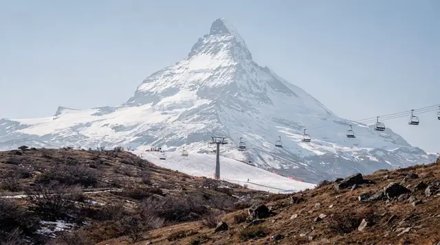
GetYourGuide does not provide a product photo for this activity — the image shows the meeting point, photographed by us.