The Pigeon Valley trail, Göreme to Uçhisar
How long is the Pigeon Valley trail between Göreme and Uçhisar?
The path covers roughly 3 km point to point, closer to 4 km with the short detours pigeon holes invite. Most walkers take 1 to 1.5 hours one way on packed earth and rock, with a modest climb concentrated in the final stretch into Uçhisar.
Walking between Göreme and Uçhisar
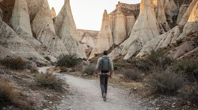
Pigeon Valley (Güvercinlik) is the walking link between Göreme and Uçhisar, and it is one of the easiest valley walks in the region to plan around, precisely because it goes from one named place to another rather than looping back on itself. The path covers roughly 3 km point to point, stretching closer to 4 km once you factor in the short detours that the pigeon houses along the way tend to invite. Most people cover it in 1 to 1.5 hours at an unhurried pace.
The elevation gain is modest and mostly back-loaded. The first half of the walk, whichever direction you start from, runs close to flat along the valley floor between orchards and cliff walls. The climb is concentrated in the stretch closest to Uçhisar, where the path rises to meet the approach road below the Uçhisar Castle plateau. It is a gentle enough gradient that it does not require any particular fitness, but it is enough to notice after a warm morning.
Underfoot, the trail alternates between packed earth, compacted rock, and a handful of short, easy scrambles where the path narrows near clusters of pigeon houses cut into the cliff face. None of these sections require hands-and-feet climbing, but sturdy, closed shoes make a real difference over trainers with a smooth sole. Waymarking exists in parts — painted arrows and the odd signpost — but it is inconsistent, and a few junctions are easy to miss if you are not paying attention. Saving the route offline before setting out, on whichever mapping app you use, removes most of the guesswork.
Why it’s called Pigeon Valley
The name is literal. For centuries, villagers around Göreme and Uçhisar carved small openings into the soft volcanic tuff along this stretch specifically to house wild pigeons. The birds were not kept for meat or eggs in any significant way here; the real product was their droppings, collected and spread as fertiliser on the vineyards and orchards that still line parts of the valley floor. Some of the openings are plain holes, while others have small painted frames or decorative surrounds around the entrance, a detail worth slowing down for rather than walking past.
You will see dozens of these pigeon houses along the walk, cut at every height from ground level to well up the cliff face, some reachable by hand and foot holds carved into the rock, most not. A few are still in occasional use by farmers today, though the practice has faded a great deal since chemical fertiliser became widely available. The valley’s other names in some older guidebooks and local usage reflect the same theme; Güvercinlik itself simply means “pigeon house” in Turkish.
Which direction to walk
Both directions work, and the choice comes down to what you want at the end.
Walking from Göreme toward Uçhisar keeps the rock castle of Uçhisar in view for a good stretch of the second half of the walk, growing larger as you approach, which makes for a clear and satisfying finish point and generally photographs better in the softer light of morning. It also means the climb comes at the end, so you arrive at Uçhisar’s cafés with the hard part already behind you.
Walking from Uçhisar toward Göreme reverses that: you start with the climb (in this direction, a descent) and end in Göreme’s town centre, which suits people basing themselves in Göreme who want to loop back to their hotel without arranging return transport. If you are walking in summer, starting from Uçhisar in the early morning also means the sun is largely behind or beside you rather than in your eyes, since the path runs roughly east–west.
Neither direction is meaningfully harder in terms of total elevation gain, since what one direction climbs the other simply descends. The difference is really about where you want to end up and what you want in your photographs on the way.
Sun exposure and timing
Pigeon Valley runs mostly in the open. Unlike some of the narrower cuts through Rose Valley or Red Valley, the cliffs here do not consistently overhang the path, so there is limited shade for most of the walk, particularly through the middle section where the valley widens out among the orchards. In the cooler months this is a non-issue and arguably a benefit, since the open aspect gives good light for photography most of the day.
In summer, it is a different story. By mid-morning in July and August, the exposed sections get hot enough that the walk is noticeably more comfortable done early. Starting by 8am, or even earlier around sunrise, avoids the worst of the heat and also tends to mean quieter trail, since Pigeon Valley sees day-trippers walking it between other stops rather than large scheduled groups. Carry water; there is nowhere to refill along the route itself.
Trailheads and getting there
The Göreme end of the trail starts near the edge of town, on the side facing the road up toward the Göreme Open-Air Museum, and is a short walk from most hotels in the centre. The Uçhisar end comes out onto the approach road just below the castle, close enough to walk into the village centre for a coffee afterwards.
Because it is a one-way walk between two towns, the practical question is how you get back to where you started. A few options work well:
| Option | Notes |
|---|---|
| Dolmuş | Göreme–Uçhisar dolmuş run frequently during the day; check the last return before setting off |
| Taxi | Widely available at both ends, a short and inexpensive hop between the two villages |
| Walk back | Doable given the short distance, but doubles the time and repeats the same scenery |
| Combine with another stop | Continue on from Uçhisar to Ortahisar or Ürgüp rather than backtracking |
If you would rather not manage logistics at all, a guided version of the walk exists that folds in hotel pickup and drop-off on both ends: a guided Pigeon Valley walk with hotel transfers included removes the return-trip planning entirely.
Doing it with a guide or on your own
Pigeon Valley does not require a guide. The trail is short, mostly well-defined, and passes between two towns rather than into open countryside, so getting seriously lost is unlikely. Anyone comfortable navigating from a saved map, in reasonable weather, can walk it independently in either direction.
Where a guide adds real value is in stitching Pigeon Valley into a longer day rather than the walk itself. Several operators pair it with a second valley on the same outing — a half-day walk covering both Love Valley and Pigeon Valley is a common combination that uses a short transfer between the two rather than trying to link them on foot, since they do not connect directly.
Others build the walk into a fuller day with an underground city, such as a day combining an underground city visit with the Pigeon Valley hike, which suits travellers without a rental car who want to cover more ground than public dolmuş timings comfortably allow.
For anyone assembling their own itinerary, Pigeon Valley slots naturally into a single day based in Göreme: see Cappadocia in one day for how it fits alongside the open-air museum and a viewpoint stop, or the dedicated best hikes in Cappadocia guide for how it compares to Love Valley, Rose Valley, and Red Valley on length and terrain. General trail conditions and precautions that apply across all of the region’s valleys — heat, loose surfaces, and phone signal — are covered separately in hiking safety in the valleys rather than repeated here.
What to look at along the way
The walk rewards a slow pace. The first thing most people notice is how the valley walls are pierced at every level: some pigeon houses are tidy square openings with a ledge, others are clusters of small holes that look like honeycomb. Stop now and then and look up rather than only ahead, because the carved frames and painted surrounds are easy to miss when you are watching your footing. The orchards on the valley floor, and the terraces that still hold vines in places, explain why the droppings were worth collecting; the whole system was a quiet piece of village farming rather than a tourist attraction, and it still reads that way.
The rock itself is part of the show. The soft tuff here was laid down by the eruptions described in the volcanoes that made Cappadocia, and the walls show their layers clearly in raking light. If the erosion of the fairy chimneys interests you, why the fairy chimneys are crumbling puts the slow collapse of these cliffs into context, and it is a good thing to have read before you stand under one.
Near the Uçhisar end the view opens out and the castle takes over the skyline. This is the moment to turn around once and look back down the valley, because the shape of the walk, a green floor between pale cliffs, is clearest from above. If you want to understand the fortress you are walking toward, Uçhisar and the castle itself are worth a short read before you set out.
Pacing the walk and where to rest
Because the route is short, it is tempting to treat it as a quick transfer on foot. It works better as a gentle half-morning. Leave room for photographs, for the pigeon houses you want to look into properly, and for a coffee at the far end. A relaxed pace also makes the final climb feel like nothing special rather than an effort.
Both ends of the walk have somewhere to sit down afterwards. In Göreme, the options are covered in viewpoint cafés in Göreme and where to eat in Göreme, and the village itself is described in Göreme. In Uçhisar, the climb ends close to the village centre, so a tea and a view of the castle is an easy reward; Turkish tea and coffee culture explains what to order and how it is served.
Water is the one thing you cannot improvise on the trail, so fill a bottle before you leave. A hat and sun protection matter more than extra layers outside the cooler months, and a light jacket is enough in the shoulder seasons. If you are unsure what to put in your bag, the Cappadocia packing list covers it, and what to wear in each season follows the same logic as for any open valley walk.
Choosing the season
Pigeon Valley changes character through the year. In spring the orchards are green and the light is soft, which makes it one of the nicest times to be on the path; see Cappadocia in spring. Summer favours very early starts, as explained above, and Cappadocia in summer gives the wider picture of how to plan the day around the heat. Autumn brings gentler temperatures and colour on the valley floor, described in Cappadocia in autumn. In winter the surface can be wet or icy in places, so take extra care on the short scrambles; Cappadocia in the snow and Cappadocia in winter are the places to check conditions and expectations. For a general view of which month suits which kind of trip, the best time to visit Cappadocia is the starting point.
Fitting Pigeon Valley into a longer stay
Because the walk is brief and sits between two bases, it combines easily with other plans. A common pattern is to walk in the early morning and spend the rest of the day on something that needs a vehicle or a booked slot. If you are watching balloons at dawn, watching the balloons without flying shows how to see them from the ground, and the valley walk can follow once the sky has emptied. For readers who prefer to compare ways of seeing the valleys, valleys on foot, quad or horseback lays out the trade-offs, and Cappadocia by scooter and motorbike is useful if you want to reach a trailhead under your own power.
Those travelling without a car will find that the walk suits getting around without a car well, since both ends are towns with transport. Public transport in Cappadocia explains the dolmuş system in more detail than the table above can. If you are tying the walk to a wider itinerary, Cappadocia in two days and Cappadocia in three days both leave room for a morning on the trail, and the slow five-day itinerary gives it the unhurried treatment it deserves.
Walkers who enjoy this kind of route often want a second, quieter valley afterwards. The valleys nobody walks is a good place to look for ideas, while Zemi Valley and Meskendir Valley are close neighbours with their own character. Where the day includes a visit to one of the underground cities, Derinkuyu is the usual choice, and a longer day through Derinkuyu, Ihlara Valley and Pigeon Valley is one way to see all three without arranging each leg yourself.
A note on respect for the valley
The pigeon houses are old, fragile and often still part of working land. Do not climb into openings that are not obviously meant to be reached, do not pull at painted frames or loose stone, and leave orchard fruit where it hangs unless someone offers it to you. Take your rubbish with you, because there are no bins along the route. Staying on the existing path also protects the soft ground, which erodes quickly once a shortcut is worn into it. These are small habits, but the valley depends on them, and they are part of what makes a walk here feel like a visit to a lived-in landscape rather than a stage set.
Pigeon Valley at a glance
| Detail | |
|---|---|
| Distance | About 3 km point to point, up to 4 km with detours |
| Walking time | 1 to 1.5 hours one way |
| Elevation gain | Modest, concentrated in the final stretch toward Uçhisar |
| Surface | Packed earth and compacted rock, a few short easy scrambles |
| Shade | Limited; mostly open along the valley floor |
| Best start time in summer | By 8am, or at sunrise |
| Waymarking | Present but inconsistent; save the route offline |
| Connects to | Göreme and Uçhisar, not directly to Love or Rose Valley |
If a set walking day works better for your plans than piecing the route together, the three-day hiking itinerary sequences Pigeon Valley alongside the region’s other valley walks, and the Göreme walking guide and Uçhisar Castle guide cover what to do at either end once the walk itself is done. For those who would rather see more ground in less time without walking the whole distance, a jeep tour through the valley covers Pigeon Valley alongside neighbouring valleys by vehicle.
Hiking & nature tours on GetYourGuide
Verified deep-linked GetYourGuide tours. Book through these links and we earn a small commission at no cost to you.
GetYourGuide does not provide a product photo for this activity — the image shows the meeting point, photographed by us.