A protected landscape, not a single attraction
Most visitors arrive in Göreme thinking of “the national park” as another name for the open-air museum ticket booth on the edge of the village. It isn’t. Göreme National Park is a protected area of roughly 300 square kilometres wrapped around Göreme, Uçhisar, Çavuşin and Ortahisar, inscribed by UNESCO in 1985 under the name “Göreme National Park and the Rock Sites of Cappadocia”.
The open-air museum is one ticketed component inside it — see the dedicated guide for that site on its own terms. The park is everything around it: the valleys you walk between villages, the abandoned settlements cut into the rock, and the open fields of fairy chimneys that line the roads with no gate at all.
That distinction matters because it changes what you should expect to see and how you should plan around it. The open-air museum is a fixed stop with a queue, a ticket window and opening hours. The national park is a landscape you move through — on the trail between Rose Valley and Çavuşin, on the roadside pullout at Paşabağ, on the ridge above Uçhisar Castle. There is no single entrance and no single visit to tick off. This page covers the park as that continuous setting, not as a rerun of the museum or a valley-by-valley itinerary — those live on their own pages, linked throughout.
The rock: two volcanoes and a very long erosion
Everything the park protects starts with geology. Cappadocia sits on a plateau at around 1,000 metres in central Anatolia, and the soft, pale rock underfoot — tuf — is compacted volcanic ash. Two volcanoes did the work: Erciyes, at 3,864 metres near Kayseri, and Hasan Dağı, at 3,253 metres to the south-west. Repeated eruptions over millions of years blanketed the region in ash, which settled and compressed into a rock soft enough to carve with hand tools but firm enough to hold its shape once cut — the same property that let people hollow entire villages and underground cities into it.
Fairy chimneys — peribacaları — are what happens when erosion is uneven. Harder basalt boulders left scattered across the tuf surface acted as caps, shielding the softer rock directly beneath from rain while everything around wore away. What remains is a column of tuf topped with a darker stone hat, sometimes single, sometimes stacked with two or three caps at Paşabağ.
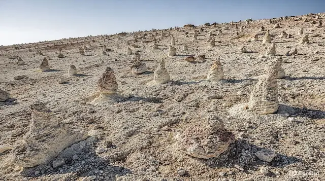
Where there was no boulder to protect a column, the result looks different again: at Devrent Valley, erosion carved freestanding shapes with no caps and no churches, purely a record of wind and water working on bare tuf. For more on how the two mountains and the ash layers connect, the volcanoes guide goes into the sequence in more detail than fits here.
Where the boundary actually runs
The park has no perimeter fence and no single road that circles it. Its boundary follows valley floors and ridgelines, so a walker crosses in and out of the protected zone without any signage marking the line. In practice, the areas travellers experience as “inside the park” cluster into a few groups:
| Area | What it is | Separate ticket? |
|---|---|---|
| Göreme Open-Air Museum | Cluster of 10th–11th century rock-cut churches | Yes, plus the Karanlık Kilise |
| Zelve | Abandoned troglodyte village, occupied until 1952 | Yes |
| Paşabağ | Multi-capped fairy chimneys, roadside | No |
| Devrent Valley | Eroded rock shapes, no churches or buildings | No |
| Çavuşin | Rock church and abandoned village above it | Small fee for the church |
| Rose, Red, Love, Pigeon, Sword, White valleys | Walking valleys threading through the park | No entry fee, marked trails |
That last row is the largest part of the park by area, and the part most visitors skip entirely in favour of the ticketed stops. The valleys are free to enter, unstaffed, and cover far more ground than the museum and Zelve combined.
Walking the valleys inside the park
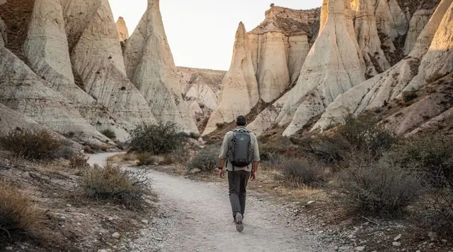
The valley network is the clearest way to feel the park as a continuous landscape rather than a list of stops. Rose Valley and Red Valley run roughly parallel, coloured by iron in the rock that turns the walls pink and rust at sunset; Love Valley is known for tall, freestanding chimneys close to Uçhisar; Pigeon Valley links Uçhisar to Göreme and takes its name from the dovecotes carved into the cliff faces, once used to collect pigeon droppings as fertiliser; Sword Valley and White Valley see far fewer walkers than the first three.
None of these charge an entry fee, and none has a gate — you simply pick up the trailhead at the edge of Göreme, Çavuşin or Uçhisar and walk in.
The trade-off is that trails fork and double back without warning, waymarking is inconsistent between valleys, and phone signal disappears in the deeper, narrower sections. There is almost no shade anywhere in the park; the tuf reflects heat and turns to fine, slippery dust that gets worse after rain. Closed shoes and at least a litre of water per hour of walking are not optional in summer. The hiking safety guide and the best hikes overview cover route choice and conditions in more depth; this page is about why the valleys carry the same protected status as the ticketed sites, not how to navigate each one turn by turn.
What the protection status actually changes
UNESCO and national park status are not just labels on a map — they set real limits on what happens in the landscape, and travellers run into them directly:
- No new digging or carving. The cave dwellings, hotels and restaurants that already exist can be renovated inside their existing footprint, but hollowing a new room into a fairy chimney or cliff face is prohibited. This is why cave-hotel supply in Göreme is fixed rather than expanding to meet demand.
- No climbing on or into unprotected formations. Fairy chimneys erode fast enough as it is; climbing on them, especially the narrower single-capped columns, loosens the base and visibly speeds up collapse. Rangers do enforce this in the busier valleys and around Paşabağ.
- Marked trails matter more than they look like they should. Off-trail walking damages the soft tuf surface and creates new erosion channels that widen every time it rains. The network of paths through Rose, Red and Pigeon valleys exists partly to concentrate foot traffic onto ground that can take it.
- Building and infrastructure are restricted near the core zones. New construction close to Göreme, the open-air museum and the main valley corridors goes through a stricter approval process than elsewhere in the wider region, which is part of why the skyline around the village has changed relatively little compared with other Turkish tourist towns.
None of this requires a permit or paperwork from a visitor — it mostly shows up as signage, occasional rangers, and areas that are fenced off after a formation has visibly started to crack or lean.
Balloons over the park
The sunrise balloon flights that Cappadocia is known for are routed specifically to pass low over the park’s fairy-chimney valleys — Love, Red, Rose and the ground around Göreme itself — which is the main reason launch sites cluster here rather than near Kayseri or Nevşehir. Flights are weather-dependent and get cancelled for wind on a meaningful number of mornings each month, more often in winter and spring, so booking the first available morning of a stay leaves a second chance if the first is scrubbed.
a sunrise balloon flight over the fairy-chimney valleysFor travellers who would rather stay on the ground and walk the same landscape at their own pace, a private guide can link the valleys, Paşabağ and Devrent into one route without the fixed stops of a bus tour.
a private guide through Göreme and the surrounding valleysTravellers short on time who still want Paşabağ and the northern part of the park covered in one outing tend to book the organised day tour instead of piecing together dolmuş connections.
a day tour covering Paşabağ and the valleys north of GöremePlanning a visit around the park rather than one site
Because the park has no single entrance, the practical question is less “when does it open” and more “how much time to give it”. A single valley walk runs one to three hours depending on route and pace; linking two valleys with stops for photos and a rest fills half a day. Anyone wanting to combine a walking valley with Paşabağ, Devrent and a slower look at Çavuşin should plan a full day rather than trying to fold it around other sightseeing — the one-day itinerary and the four-day hiking itinerary both build around that reality rather than against it.
Timing follows the same logic as anywhere in Cappadocia: April to June and September to October give the most comfortable walking temperatures and the clearest light for photography, covered in more detail on the viewpoints guide. Midday in July and August pushes past 30 degrees with almost no shade on the valley floors, and winter walking is genuinely different — snow settles on the fairy chimneys and can make trails slippery or impassable in places, which is worth planning around rather than discovering on the ground.
Visitors who want the underground-city side of the region’s protected heritage, which sits outside the park boundary proper but is often bundled with it on tours, will find that covered separately.
a private tour combining the open-air museum with an underground cityFrequently asked questions about Göreme National Park
Is Göreme National Park the same thing as the Göreme Open-Air Museum?
No. The open-air museum is one fenced, ticketed site inside the park — a cluster of tenth and eleventh-century rock-cut churches. The national park is the much larger protected area around it, covering valleys, abandoned villages and fairy-chimney fields that have no gate or entry fee of their own.
How big is Göreme National Park and where does it start and stop?
The protected zone covers roughly 300 square kilometres, wrapping around Göreme, Uçhisar, Çavuşin and Ortahisar and the valleys between them. It has no single perimeter fence; the boundary follows the ridgelines and valley floors, so you cross in and out of it on foot without noticing a gate.
Do I need a ticket to enter the national park?
No single ticket covers the whole park. Some sites inside it charge entry — the open-air museum, Zelve and a handful of churches — while most valley trails and roadside formations, including Paşabağ and Devrent, are free to walk or view.
Why is the rock shaped like this — where do the fairy chimneys come from?
Eruptions from Erciyes and Hasan Dağı buried the region in volcanic ash that compressed into soft tuf. Harder basalt boulders scattered across the surface protected the tuf directly beneath them from rain; everything around eroded away over hundreds of thousands of years, leaving columns capped with a darker stone hat.
Can I climb into a fairy chimney or dig a new cave?
No. The formations are protected under the national park and UNESCO listing, and climbing on or into them accelerates the erosion that is already wearing them down. Stick to marked trails and existing openings; rangers do patrol the busier valleys.
Which valleys can I walk without a guide?
Rose, Red, Love, Pigeon, Sword and White valleys all have marked trails that link Göreme, Çavuşin and Uçhisar on foot, and none charge an entry fee. Paths do fork and repeat, phone signal drops in the deeper sections, and there is very little shade, so carry water and a downloaded map.
How much time should I set aside for the park beyond the open-air museum?
A single valley walk takes one to three hours depending on the route; linking two valleys, with stops, fills half a day. Travellers who want to see Paşabağ, Devrent and a walking valley in the same outing should plan a full day rather than squeezing it around other sightseeing.
Does the balloon flight route fly over the national park?
Yes — sunrise balloon flights are timed and routed to pass low over the fairy-chimney valleys inside the park, which is the main reason the launch sites cluster around Göreme rather than elsewhere in Cappadocia.