Meskendir Valley hike: Göreme to Ortahisar on foot
How long is the Meskendir Valley hike and where does it start and end?
The walk runs roughly 4 kilometres between Göreme and Ortahisar, taking about 1.5 to 2 hours at an easy pace with some short scrambles over rock steps. Most walkers start from the eastern edge of Göreme and finish near the base of Ortahisar Castle, though the route works in either direction.
Walking from Göreme to Ortahisar the slow way
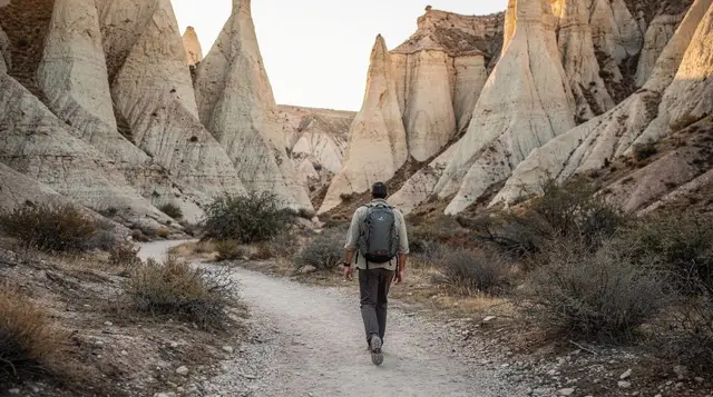
A road links Göreme and Ortahisar in about ten minutes by car or dolmus. Meskendir Valley links the same two villages on foot, and it takes closer to two hours, because the path follows the valley floor rather than the ridge the road runs along. That trade-off is the whole point of walking it: instead of a car window view of the plateau, you get vineyards, apricot orchards, cave entrances cut into tuff walls, and a stretch of open canyon with barely another walker in sight.
Meskendir sits just west of the better-known Güllüdere valley, which most guidebooks call Rose Valley, and west again of Zemi Valley, the route that runs more directly north out of Göreme. None of the organised colour-coded circuits — Red, Green or Blue Tour — passes through Meskendir, which is the main reason it stays quiet even in August while Rose Valley and Red Valley fill with tour groups at the golden-hour photo stops.
Distance, gradient and what the surface is like
The full walk between Göreme and Ortahisar runs roughly 4 kilometres, and at an unhurried pace with a few stops it takes 1.5 to 2 hours. The gradient is gentle by regional standards — there’s no single steep climb — but the valley floor rises and falls in short sections as the path skirts around outcrops and drops into side gullies, so total elevation gain over the walk adds up to somewhere around 100 to 150 metres even though you never feel like you’re climbing a hill.
The surface itself is packed dirt and bare tuff for most of the route, occasionally softened by cultivated soil where it passes through orchard plots. A handful of short sections require scrambling over eroded rock steps or loose scree, nothing that needs hands-and-feet climbing but enough that trainers with worn soles are the wrong footwear. After rain the tuff dust turns slick within minutes, and a few of those scramble sections become genuinely awkward — if it has rained in the last day, treat the trail as a maybe rather than a plan.
Waymarking is inconsistent. The lower stretches near both villages are well trodden and obvious. The middle section, where the valley narrows and side paths branch off towards cave dwellings, dead-end viewpoints and connecting tracks to neighbouring valleys, thins out and occasionally forks without any marker at all. An offline map on your phone — Maps.me or a downloaded Google Maps tile — solves this in five minutes before you set off and is worth doing regardless of how confident the trail looks at the entrance.
Starting from Göreme
Most walkers begin from the eastern edge of Göreme, picking up the valley entrance a short walk from the village centre rather than from the open-air museum side. The first stretch runs through cultivated plots — small vineyards and orchard terraces worked by local families — before the valley walls close in and the path settles onto the canyon floor proper. This opening section is flat, shaded intermittently by fruit trees, and an easy way to judge whether the rest of the walk suits your group before committing to the full distance.
If you’d rather not find the entrance yourself, or want the local knowledge that fills in what a self-guided walk misses — which caves were storage rooms, which were homes, why the vines are planted where they are — a private guide covers exactly this route and the adjoining Güllüdere ground:
a private guided hike through Meskendir and GüllüdereFinishing at Ortahisar
The valley closes in gradually as it approaches Ortahisar, and the last kilometre climbs slightly as the path meets the base of the rock outcrop the village is built around. Walkers usually emerge near the foot of Ortahisar Castle, from where it’s a short uphill walk into the village centre for lunch, water refills and a bus or taxi back to Göreme if you don’t fancy retracing your steps.
This guide covers the walk itself rather than what to do once you’re in Ortahisar — for the castle climb, the citrus-curing caves and the rest of the village, the separate Ortahisar guide picks up from where this one ends.
What you’ll actually see along the way
The character of Meskendir Valley is greener and more agricultural than its neighbours. Where Rose Valley and Red Valley are dominated by bare pink and red tuff formations with almost nothing growing on them, Meskendir alternates between mineral canyon walls and working land — vines trained low against the heat, apricot and almond trees, small stone-walled plots that local families still tend. Cave openings are cut into the cliff faces at intervals, some clearly old storage rooms for produce, others former dwellings now empty. None are signposted or interpreted; this isn’t a museum route, it’s a working valley that happens to be walkable.
The tuff walls themselves are the same volcanic rock as the rest of the region — soft, easily eroded, streaked in bands of cream, grey and rust depending on mineral content — but Meskendir’s formations are less dramatically sculpted than the fairy chimneys further north around Paşabağ or Zelve. There are no isolated cone-shaped pillars here; instead the walls rise as continuous cliffs, undercut and pitted, with the orchards and vines softening what would otherwise be a fairly stark canyon. If you’ve already walked Rose Valley or Red Valley and want a contrast rather than a repeat, Meskendir gives you one.
Sun exposure and starting early
Roughly the middle third of the route crosses open ground where the valley widens and the orchard cover disappears — bare tuff on both sides, full sun overhead, and nowhere to shelter. In spring and autumn this is a mild inconvenience. In July and August it’s the reason to start early. Temperatures on the plateau regularly reach 30 to 35 degrees on summer afternoons, and that open stretch with no shade and no breeze at valley-floor level is unpleasant to cross after about ten in the morning.
Starting from Göreme by 7.30 or 8am in summer gets you through the exposed section while it’s still cool, and has the side benefit of a good chance of a quiet trail — this is also roughly when the last hot air balloons of the morning are descending, visible over the valley walls from a few points along the route if timing lines up. Carry at least a litre of water per person regardless of season; there are no shops, kiosks or refill points anywhere on the walk, only what you bring in from Göreme or Ortahisar.
Guided versus self-guided
Meskendir doesn’t require a guide the way the underground cities or some of the archaeological sites do — there’s nothing to unlock or explain in the way a cave church needs context. Most of what makes the walk worthwhile is visible without commentary: the vines, the orchards, the cave openings, the contrast with the barer valleys nearby. Confident walkers with an offline map and decent footwear manage it independently without difficulty.
A guide earns its cost in the sections where the path forks without signage, and in the local detail a self-guided walker would simply miss — which orchard belongs to which family, how the storage caves were used, why this valley never made it onto the tour company circuits. It’s also the more sensible option after rain, when the scramble sections need someone who already knows which line to take.
For a different valley on the same theme — dramatic rock rather than orchards, and a start timed around the morning balloon launch — Rose Valley has its own guided sunrise option:
a sunrise hike through Rose Valley with balloon viewsCombining Meskendir with other things to do
Because the walk is short and the terrain is gentle, it fits easily into a half day alongside something else, rather than needing a day of its own. Walkers based in Göreme often pair it with an early finish in Ortahisar for lunch, then a taxi or dolmus back rather than retracing the whole valley on tired legs. Others treat it as the quiet counterpart to a louder day — walking Meskendir in the cool of the morning, then joining an organised excursion into terrain that’s harder to see on foot, such as an underground city combined with valley walking:
a day combining an underground city visit with a Pigeon Valley walkIf your group has mixed fitness levels, or simply prefers not to walk at all, the same stretch of countryside is also covered by vehicle-based options that take in several valleys in a single outing:
a jeep tour through the valley landscape around GöremePlanning notes
The table below sets out the practical basics against the two valleys walkers most often compare Meskendir to, since the choice usually comes down to time available and how much sun exposure you’re willing to accept.
| Route | Distance | Time | Shade | Crowds |
|---|---|---|---|---|
| Meskendir Valley (Göreme–Ortahisar) | ~4 km | 1.5–2 hrs | Patchy — orchards low, open middle section | Low |
| Rose Valley (Güllüdere) | ~4–5 km | 1.5–2.5 hrs | Minimal, mostly bare tuff | Moderate to high at sunset |
| Zemi Valley | ~3–4 km | 1–1.5 hrs | Some orchard cover | Low to moderate |
None of these figures are exact to the metre — trail conditions and the route you personally take through the unmarked middle sections will shift the numbers slightly either way. Treat them as planning ranges, not guarantees, and build in extra time rather than less.
For wider hiking logistics that apply across all of Cappadocia’s valleys — footwear, water, heat and what to do if a path disappears — see the general hiking safety guide and the best hikes in Cappadocia overview, which places Meskendir alongside the region’s other valley walks. If you’re building out a longer stay around walking rather than tours, the four-day hiking itinerary works Meskendir in alongside Rose, Red and Ihlara. For village-based walking either side of the valley, the Göreme walking guide and the Ortahisar guide linked above cover what to do at each end.
Anyone travelling with mobility limitations should read the limited mobility guide first — the scramble sections here rule the route out for wheelchair users and anyone unsteady on loose rock. And if you’re visiting in peak summer heat, the Cappadocia in summer guide has the wider context on timing outdoor plans around the hottest hours, alongside the general packing list for footwear and sun protection. For the full category of walking routes across the region, the nature and hiking hub lists them together.
Meskendir Valley hike: common questions
How long does the Meskendir Valley hike take?
Budget 1.5 to 2 hours for the roughly 4-kilometre walk between Göreme and Ortahisar at an unhurried pace, longer if you stop often for photos or shade. It takes considerably longer on foot than the 10-minute drive by road between the same two villages, since the path winds along the valley floor rather than cutting straight across.
Is the Meskendir Valley trail well marked?
Loosely. The main path is well trodden and easy to follow for most of its length, but side tracks branch off towards orchards, cave entrances and dead-end viewpoints, and signage thins out in the middle section. Downloading an offline map before you start is worth the five minutes it takes.
Can beginners or families walk Meskendir Valley?
Yes, with caution. The gradient is gentle by Cappadocia standards, but there are a handful of short scrambles over loose rock and eroded steps where a hand is useful, and no railings anywhere. It suits families with older children who are steady on uneven ground rather than very young ones or anyone unsteady on their feet.
Is there shade on the Meskendir Valley walk?
Patchy. The lower stretches through orchards and vineyards give some cover from fruit trees, but a good third of the route crosses open ground with bare tuff on both sides and no shade at all. In July and August this section gets uncomfortably hot by mid-morning.
What should I bring on the Meskendir Valley hike?
Closed shoes with grip, at least a litre of water per person, a hat and sun cream even in shoulder season, and enough charge on your phone for offline maps since signal drops in the deeper sections. There are no shops, taps or toilets anywhere along the route.
Does the Meskendir Valley path connect to other valleys?
It runs close to Güllüdere, the valley locals call Rose Valley, and to Kızılçukur, and unmarked side paths do connect across at a few points. Following those connections without local knowledge is how people end up on a ridge with no way down, so stick to the main Meskendir route unless you are walking with someone who knows the junctions.
Is Meskendir Valley busier than Rose Valley or Red Valley?
No, noticeably quieter. It sits just west of the valleys most tour groups walk, and because it isn’t part of the standard Red Tour or Green Tour itinerary, you can walk long stretches without meeting anyone, even in high season.
Hiking & nature tours on GetYourGuide
Verified deep-linked GetYourGuide tours. Book through these links and we earn a small commission at no cost to you.
GetYourGuide does not provide a product photo for this activity — the image shows the meeting point, photographed by us.