Sword Valley: the quiet walk between Göreme and Çavuşin
How long is the Sword Valley walk and is it easy to follow?
The main path through Sword Valley (Kılıçlar) runs roughly 3 to 4 kilometres one way, with gentle but uneven descents rather than a real climb. Waymarking is patchier than in Rose or Pigeon Valley, and the trail splits at a few points, so it's usually walked as part of a longer route rather than as a standalone outing.
Sword Valley sits between Göreme and Çavuşin, a few hundred metres from Rose Valley and easy to overlook because it doesn’t have its own car park, its own café, or a name that shows up on the big tour-company banners in town. That’s also the reason to walk it: fewer people, and rock formations that are, if anything, more dramatic than the valleys that get the footfall.
Why it’s called Sword Valley
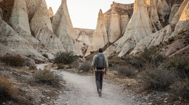
The Turkish name is Kılıçlar, “swords,” and it describes the shape rather than any story attached to the place. Where Rose Valley next door has softer, rounded slopes coloured pink and orange by iron oxide in the tuff, Sword Valley narrows into tall, straight-edged rock blades with the sides pressed close together. In the lower stretch the walls rise well above head height on both sides, and the light gets cut off early in the afternoon, which is part of why it photographs differently from anywhere else near Göreme: hard shadow lines instead of the glow that Rose and Red Valley are known for.
Trail length and terrain
The core walk runs roughly 3 to 4 kilometres one way, depending on which entry and exit points you use. There’s no real elevation gain in the way a mountain trail would have one — Cappadocia’s valleys are cut down into the plateau, not up out of it — but the path drops and rises repeatedly as it crosses side gullies, and a few sections require a short scramble over loose rock or a step down a worn tuff ledge. None of it is technical, but it isn’t a flat stroll either. Trainers with decent grip are fine; sandals are not.
Compared with Pigeon Valley, which has a clear, single-file path the whole way, Sword Valley’s surface is inconsistent. Some stretches are packed dirt, others are loose gravel over rock, and after rain the tuff turns genuinely slick. It dries out fast in summer heat, but a walk right after a storm is worth postponing by a day.
Entry and exit points
Most people start from the Göreme side, picking up the trail from a track off the road heading toward Çavuşin, close to where several unofficial paths into the valley system begin. There’s no ticket booth and no formal car park — just a widened verge where local guides leave vehicles. The other end drops down near the Çavuşin road, a short walk or dolmuş ride from the village itself.
The valley also connects sideways into Rose Valley through a linking path partway along, which is the detail that matters most for planning: very few people walk Sword Valley in isolation. It’s normally the connecting leg of a longer route, either Göreme to Rose Valley via Sword, or the reverse.
Waymarking: less reliable than the popular valleys
This is the point worth being honest about. Rose Valley and Pigeon Valley have had their main routes walked and re-walked by thousands of tourists a year for long enough that the correct path is obvious even without markers, and paint blazes reinforce it at the junctions that matter. Sword Valley doesn’t get that volume of traffic, so paint fades, gets missed on repainting rounds, and in a few places simply isn’t there.
The trail also splits at a handful of points where herding tracks, old farming paths, and the main hiking route all head off from the same spot, and it isn’t always visually clear which one is the through-route. Our hiking safety guide for the valleys covers this splitting-trail problem in more depth, because it isn’t unique to Sword Valley — it shows up in several of the quieter canyons — but it happens more often here than in Rose or Pigeon Valley specifically.
Practically, that means: download an offline map or GPS track before you go, don’t assume the widest-looking path is the correct one, and build in slack for a wrong turn. Mobile signal drops out at the bottom of the canyon, so don’t count on looking something up once you’re down there.
What it looks like, and why people rate it
The appeal is the geometry. Where Devrent Valley is open and strange with isolated formations dotted across flat ground, Sword Valley is the opposite: a tight, enclosed corridor with walls that lean in overhead in places. Some sections narrow enough that you can touch both sides. There are a few cave openings and old pigeon holes cut into the rock at points along the route, evidence of the same dovecote-carving tradition that gives Pigeon Valley its name, but nothing here has been developed for visitors — no ladders, no lighting, no signage explaining what you’re looking at.
Early morning is the best time to walk it, both for temperature and for the chance of having it to yourself. Because it isn’t on the standard day-trip circuit, it rarely sees the mid-morning bunching that hits the Göreme Open Air Museum or Pigeon Valley’s main viewpoint.
Reading the canyon as you walk
Because the path is not always obvious, it helps to walk with your eyes up as much as down. The blades of rock give you a running sense of where you are: when the walls close in and the light drops, you are in the tightest part of the corridor; when the sky opens and the sides slump into rounded slopes, you are drifting toward the softer scenery of Rose Valley. Treat that change in the rock as a landmark, and stop to check your map whenever it happens rather than only when you feel lost.
Look, too, at the ground. A path that has been used by walkers is usually worn smooth and pale, while herding tracks tend to be narrower and scuffed with animal prints. If the surface you are following gets thinner and fainter, it is often a sign that you have slipped onto a side track. Turning back early costs a few minutes; carrying on for another half hour usually costs much more.
A relaxed pace and where to stop
Sword Valley rewards slowness. There are no cafés and no benches, so the stops are the ones you make yourself: a flat ledge in the shade of a rock blade, a wide spot where the canyon opens enough to sit down, a corner where the walls frame a patch of sky. Take your time in the narrowest stretch, where the colour of the tuff shifts between cream, rust and grey depending on the angle of the sun. It is also the place where sound changes, and a quiet morning here feels very different from the busier paths around Göreme.
If you are walking with a partner or a group, agree in advance on a meeting point in case someone stops to photograph and falls behind. With forks in the path and no phone signal at the bottom of the canyon, it is easy to lose each other for a few minutes, and an agreed rule such as “wait at the next junction” removes the worry.
Photography in the narrow sections
The enclosed walls make exposure tricky. A bright sky above and deep shadow below can fool a phone camera, so tap on the rock face rather than the sky and let the highlights fall where they fall. The reflected light off sunlit tuff gives the lower walls a warm glow that is lovely at close range, and it is worth waiting for a moment when nobody else is in the frame. For a wider sense of the surrounding landscape, our viewpoints guide lists places where the valleys can be seen from above, which makes a good counterpart to a walk inside one.
Combine it, don’t walk it alone
Given the connecting path to Rose Valley and the relatively short standalone distance, treat Sword Valley as one leg of a route rather than a full day out. A common combination:
| Route | Approx. distance | Approx. time |
|---|---|---|
| Sword Valley only (Göreme to Çavuşin road) | 3–4 km | 1.5–2 hours |
| Sword Valley into Rose Valley | 6–7 km | 3–3.5 hours |
| Sword and Rose Valley, extended to Love Valley | 9–10 km | 4.5–5.5 hours |
If you’d rather cover the same ground without the route-finding, a quad safari through Sword, Love and Rose Valleys follows a version of this same corridor on wheels rather than on foot, which solves the waymarking problem entirely if that’s your main hesitation. For a walking option with someone who already knows the correct forks, a guided walk through the lesser-known valleys and villages typically includes Sword Valley alongside similarly quiet routes.
Doing it independently
Walking Sword Valley without a tour is entirely possible and doesn’t require any special fitness — this isn’t Ihlara Valley or the Aladağlar. What it does require is a bit more preparation than the marked valleys: a downloaded map, a full water bottle (there’s no shade to speak of and nowhere to refill), and a realistic time buffer in case you take a wrong branch and have to backtrack.
Our guide to seeing Cappadocia without a tour covers the broader logistics of independent valley walking, and the best hikes in Cappadocia roundup places Sword Valley alongside the other routes worth knowing about if you’re building your own itinerary.
If you’d rather not navigate the forks at all, a guided hike with hotel transfers through the nearby valley network removes that variable, with a guide who knows which fork is which and hotel pickup built in so you’re not relying on an infrequent dolmuş at the far end.
Getting there and back
There’s no dolmuş stop directly serving either end of the trail. Most people either start on foot from central Göreme (the trailhead is a walkable distance from the village, roughly 15–20 minutes), arrange a taxi drop at one end and walk out to a road at the other, or join a tour that handles both ends. If you’re walking the full Sword-to-Rose combination, you’ll finish closer to the Rose Valley viewpoint car park above Çavuşin, where taxis and occasional dolmuş traffic pass.
Respecting the valley
Nothing in Sword Valley is managed for visitors, which means the place stays as good as walkers leave it. Take every wrapper and bottle back out with you, stay on existing paths rather than cutting across fragile slopes, and leave the old dovecotes and cave openings untouched. The tuff is soft and crumbles easily, so climbing on the rock blades is both unwise and damaging. If you meet farmers or shepherds on the track, a friendly greeting goes a long way, and it is courteous to step aside for animals.
When to go
April to June and September to October give the most comfortable walking temperatures and the best light for photography in the narrow sections. Midsummer (July–August) is workable early in the morning, but the enclosed parts of the canyon trap heat by midday, and there’s no shade to retreat to. Winter walking is possible on dry days but the tuff surface turns treacherous when wet or icy, and daylight hours are shorter — check our best time to visit Cappadocia guide for the seasonal trade-offs across the whole region.
What to bring
- Closed shoes with grip — trainers or light hikers, not sandals
- At least a litre of water per person, more in summer
- A downloaded offline map or GPS track of the route
- Sun protection: hat and sunscreen, since shade is minimal outside the narrowest sections
- A basic first-aid kit if walking independently, given the patchy waymarking
Our general Cappadocia packing list covers the rest of what you’d want for a valley-walking day beyond the trail-specific items above.
Alternatives if the forks put you off
If the idea of an unmarked trail with splitting paths sounds like more hassle than it’s worth, Sword Valley isn’t the only option nearby. Rose Valley and Love Valley both have clearer, better-trodden paths and similar rock scenery, and are covered in our dedicated Rose Valley hike and Love Valley walk guides.
A guided horseback ride through the valleys is another way to take in the same terrain without worrying about navigation at all, and it covers ground faster than walking if your time in the region is limited. For a broader look at how the valleys fit into a multi-day plan, our four-day hiking itinerary sequences Sword Valley alongside the more established routes, and the nature and hiking hub lists every walking option in the region if you want to compare distances and difficulty before deciding where to spend a morning.
Sword Valley questions answered
How long does the Sword Valley walk take?
Allow 1.5 to 2 hours for the main stretch alone, or half a day if you link it to Rose Valley or Red Valley, which is how most people actually walk it.
Is Sword Valley suitable for beginners?
It’s manageable for a fit beginner in dry conditions, but the patchy waymarking and the forks near the middle section make it less forgiving than Pigeon or Rose Valley. First-time hikers often do better with a guide here.
Where does Sword Valley start and finish?
Most walkers enter from the edge of Göreme, near the road toward Çavuşin, and exit either into Rose Valley to the south or down toward the Çavuşin road to the north. Both ends have informal, unsigned parking.
Why is it called Sword Valley?
Kılıçlar means “swords” in Turkish, a reference to the tall, narrow rock blades that line the canyon rather than to any historical weapon or battle.
Can I walk Sword Valley on my own without a guide?
Yes, but bring a downloaded map or GPS track rather than relying on painted markers, and expect to backtrack at least once if you take a wrong fork.
Does Sword Valley connect to Rose Valley?
Yes. A path links the two, and walking Sword into Rose (or the reverse) is the standard way locals and guides cover both in one outing.
Is there shade or water along the way?
Very little shade and no reliable water source. Carry at least a litre per person and start early if you’re walking between May and September.
What should I wear for the Sword Valley trail?
Closed, grippy shoes rather than sandals. The tuff surface is loose gravel in places and can be slick after rain, and there are short scrambles over rock steps.
Hiking & nature tours on GetYourGuide
Verified deep-linked GetYourGuide tours. Book through these links and we earn a small commission at no cost to you.
GetYourGuide does not provide a product photo for this activity — the image shows the meeting point, photographed by us.