A valley that exists to get you somewhere
Most of the named valleys around Göreme are destinations in their own right: you walk in, look around, and walk back out the way you came. Meskendir Valley works differently. It runs roughly between Göreme and Ortahisar, and most people who walk it are doing exactly that — covering the 45 minutes to an hour and a half between the two villages on foot instead of taking a taxi or waiting for a dolmuş. That single fact shapes everything else about the place: it is quieter than the valleys built around a single showpiece view, and it rewards someone who wants to actually get somewhere rather than someone looking for a short loop back to a car park.
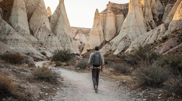
The valley cuts through the same soft volcanic tuff as Rose Valley and Red Valley next door, but the erosion here has produced narrower, less photogenic walls in places, with fewer of the pink-and-white striations that make Rose and Red Valley popular at sunset. What it does have is fairy chimneys, pigeon houses cut into the cliffs, a scattering of small rock-cut chapels, and long stretches where you will not see another walker. If you have already done Pigeon Valley or Rose Valley and found them busier than expected, Meskendir is the obvious next step — the same kind of tuff-canyon walking, with a fraction of the footfall.
Terrain: mostly tuff, with a few sections that are not for everyone
The path through Meskendir Valley is not a maintained trail in the way a national park path would be. It is a walked route through soft volcanic rock, and the going varies a lot over its length. Much of it is straightforward: packed dust and gravel underfoot, gentle gradients, easy to follow. But there are stretches where the path narrows against a rock face, drops down short scrambly sections, or asks you to pick a line across loose scree on a slope. None of this requires ropes or technical climbing, but it is a step up from the wide, flat gravel of somewhere like Devrent Valley or the paved sections of the Göreme Open-Air Museum.
Anyone with a fear of exposed edges, unsteady footing, or limited mobility should treat this as a route to skip in favour of an easier valley — see our guide to hiking safety in the valleys before committing. Closed, sturdy shoes with grip are not optional here; trainers with a smooth sole will slip on the dusty tuff, and sandals are a genuinely bad idea on the scree sections. Trekking poles help on the steeper drops if you already use them.
The biggest practical warning is what happens after rain. Tuff sheds water fast and turns slick, and the informal path — which is really a set of worn lines through soft rock rather than a signed trail — can partly wash out or become genuinely hard to follow. Local guides and hotel staff in both Göreme and Ortahisar will tell you the same thing: if it has rained in the last day, don’t attempt Meskendir alone, or leave it for a different day. There is no waymarking to fall back on, and a wrong turn in a side ravine can eat an hour before you realise you need to backtrack.
No water, no shade, no shortcuts
Unlike Rose Valley or the approach to Uçhisar Castle, Meskendir Valley has no café, no drinks stand, and no fountain anywhere along its length. Whatever water you carry in is the only water you will have until you reach Göreme or Ortahisar at the other end. In summer heat, two litres per person is a sensible minimum for the full crossing, more if you are walking in the middle of the day rather than the morning. Shade is limited to the shadow of the canyon walls at certain times of day; there is no tree cover to speak of. Mobile signal drops out in the lower sections of the canyon, the same as in most of the valleys around here, so this is not a route to rely on your phone for navigation or for calling ahead.
None of this makes Meskendir dangerous for a reasonably fit, well-prepared walker. It does mean it is not the valley to attempt underdressed, under-hydrated, or in flip-flops because “it’s just a short walk between two villages.” Budget the full 45 minutes to 90 minutes of walking time, add extra for photo stops, and start early enough that you are not finishing in the hottest part of the afternoon.
Why it beats the crowds at Rose, Red and Pigeon Valley
Rose Valley and Red Valley get busy for a simple reason: they photograph beautifully at sunset, and every tour van and every independent traveller with a camera knows it. Pigeon Valley gets crowded because it sits right on the main viewpoint route out of Uçhisar and doubles as a scenic backdrop for the road above. Meskendir has none of that pull. It doesn’t have a headline sunset view, it isn’t on the standard Red Tour or Green Tour itinerary, and it doesn’t connect neatly to a car park with a view. The result is a valley that, on most days, you can walk for long stretches without meeting anyone.
| Valley | Typical crowd level | Terrain | Best used for |
|---|---|---|---|
| Meskendir Valley | Low | Tuff, some scrambly sections | Walking between Göreme and Ortahisar |
| Rose Valley | Moderate–high at sunset | Tuff, mostly easy | Sunset views, photography |
| Red Valley | Moderate–high at sunset | Tuff, mostly easy | Sunset views, connects to Rose Valley |
| Pigeon Valley | High near viewpoints | Easy, some steps | Uçhisar–Göreme link, road-view photos |
| White Valley (Bağlıdere) | Low–moderate | Easy, open ground | Short walk near Ortahisar |
If your priority is solitude and you are staying in either Göreme or Ortahisar, Meskendir is one of the few valleys left where you can walk for an hour and genuinely have the tuff to yourself.
Don’t confuse it with White Valley
Meskendir Valley is sometimes mixed up with White Valley, also known locally as Bağlıdere, which also runs near Ortahisar. They are not the same walk. White Valley follows a different, generally easier and more open route close to Ortahisar, with pale, bright rock faces that give it its name, and it does not function as a direct Göreme–Ortahisar link in the way Meskendir does.
If a driver, guide or hotel recommends “the valley near Ortahisar” without naming it, it is worth asking specifically which one they mean — the terrain and the time commitment are different enough to matter, and White Valley is the gentler option of the two if you are unsure about the scrambly sections described above. There’s a dedicated write-up on the White Valley hike at Bağlıdere if that sounds like the better fit.
Walking it as a link between Göreme and Ortahisar
This is the practical case for Meskendir Valley, and it is a good one. If you are based in Ortahisar — which has become a popular, quieter alternative to staying in central Göreme — and you want to reach Göreme’s restaurants, shops or the Göreme Open-Air Museum without booking a taxi or waiting on the dolmuş schedule, walking through Meskendir Valley is a genuinely pleasant way to do it, weather permitting. The same works in reverse: from Göreme, it’s a scenic approach to Ortahisar’s rock-cut storage caves and the castle rising above the village.
Realistic timing: allow 45 minutes for a brisk, direct walk with no stops, or up to 90 minutes if you’re pausing for photos, exploring a side path, or taking it slowly over the rougher sections. That makes it a comfortable half-morning or half-afternoon activity rather than an all-day outing — pair it with lunch or a coffee stop at whichever end you finish, and it fits neatly either side of another activity like the Ortahisar walking guide or a slower morning in Göreme itself.
a private guided hike through Meskendir and Güllüdere is worth considering if you’d rather not navigate the unmarked sections alone, especially after recent rain or if this is your first valley walk in Cappadocia. A local guide knows the current state of the path, carries water, and can point out the rock-cut chapels and pigeon houses that are easy to miss without context.
What else to build around it
Because Meskendir isn’t a full-day destination on its own, most visitors fold it into a wider day rather than treating it as the whole plan. If you’re building a hiking-focused day or two, our guide to the best hikes in Cappadocia sets Meskendir alongside Rose Valley, Red Valley and the Ihlara Valley canyon so you can see how they compare for distance and difficulty, and the Cappadocia hiking itinerary strings several valley walks together over a few days without repeating terrain.
For a morning that isn’t only about walking, plenty of visitors combine the valley crossing with a hot air balloon flight the same day, since balloons launch at first light and are grounded well before the day heats up enough to make hiking uncomfortable.
A sunrise hot air balloon ride over the valleys gives you an aerial view of Meskendir and its neighbours before you walk through them at ground level a few hours later, and if the flight is cancelled for wind — which happens on several mornings a month, more often in winter and spring — a balloon watching tour is a reasonable way to still catch the sunrise spectacle from the ground.
If you’d rather cover more of the region than a single valley in one go, a South Cappadocia day tour or a private, fully customisable tour can combine an underground city or the Ihlara Valley with a shorter stop near Meskendir or Ortahisar, useful if you’re short on days and don’t want to walk the full valley crossing yourself.
Practical notes before you go
Set out with proper walking shoes, at least a litre and a half of water per person (two in summer), sun protection, and a downloaded offline map if you’re navigating without a guide, since mobile signal is unreliable in the lower canyon. Don’t attempt the crossing in the day or two after heavy rain — ask at your hotel in Göreme or Ortahisar for a same-day read on trail conditions, since staff generally know within a few hours of rain whether the path is passable. There’s no entry fee and no gate, so there’s nothing to book in advance unless you’re going with a private guide.
If you’re staying in Göreme and simply want to see Meskendir without committing to the full village-to-village walk, you can enter from either end and turn back after twenty or thirty minutes — the lower stretches near Göreme are among the easier walking and give a fair sense of the valley without the scrambly sections further along.
Common questions about walking Meskendir Valley
How long does it take to walk from Göreme to Ortahisar through Meskendir Valley?
Budget 45 minutes for a direct, unhurried walk, or up to 90 minutes with photo stops and a slower pace over the rougher sections. Add extra time if you’re unfamiliar with the route or walking after recent rain, when the path is harder to follow.
Is Meskendir Valley difficult to walk?
Most of it is straightforward tuff walking, but there are a few narrow, scrambly sections with loose scree that are a step up from an easy valley walk. It suits a reasonably fit, confident walker rather than someone looking for a flat, easy stroll — for that, White Valley or Devrent Valley are gentler choices nearby.
Is there water or shade along the way?
No. There are no fountains, cafés or reliable shaded stretches anywhere along the route between Göreme and Ortahisar. Carry all the water you’ll need, at least a litre and a half per person, more in summer.
Can I walk Meskendir Valley after it rains?
It’s best avoided the day of or the day after significant rain. The path is unmarked and cut into soft volcanic tuff, which turns slick and can partly wash out, making the route genuinely hard to follow in places. Ask locally about recent conditions before setting out.
Is Meskendir Valley the same as White Valley?
No. They are separate valleys near Ortahisar. Meskendir runs as a direct link between Göreme and Ortahisar with some scrambly terrain, while White Valley, also called Bağlıdere, follows a different, generally easier route with paler rock and no direct village-to-village function.
Do I need a guide to walk Meskendir Valley?
Not strictly, but a guide is worth considering if it’s your first valley walk, if there’s been recent rain, or if you’d rather not navigate unmarked forks in the path yourself. A private guided hike through Meskendir and neighbouring Güllüdere also points out rock-cut chapels and pigeon houses that are easy to walk past without knowing what to look for.
Is Meskendir Valley crowded like Rose or Pigeon Valley?
No, and that’s its main appeal. It isn’t on the standard tour circuit and doesn’t have the sunset draw of Rose or Red Valley, so on most days you’ll walk long stretches without meeting other visitors.
What should I wear or bring for the walk?
Closed shoes with real grip, not trainers with smooth soles or sandals. At least a litre and a half of water per person, sun protection, and a downloaded offline map, since mobile signal is unreliable in the lower canyon.